The Abandoned Hofheimer Grotto in Warren, New Jersey

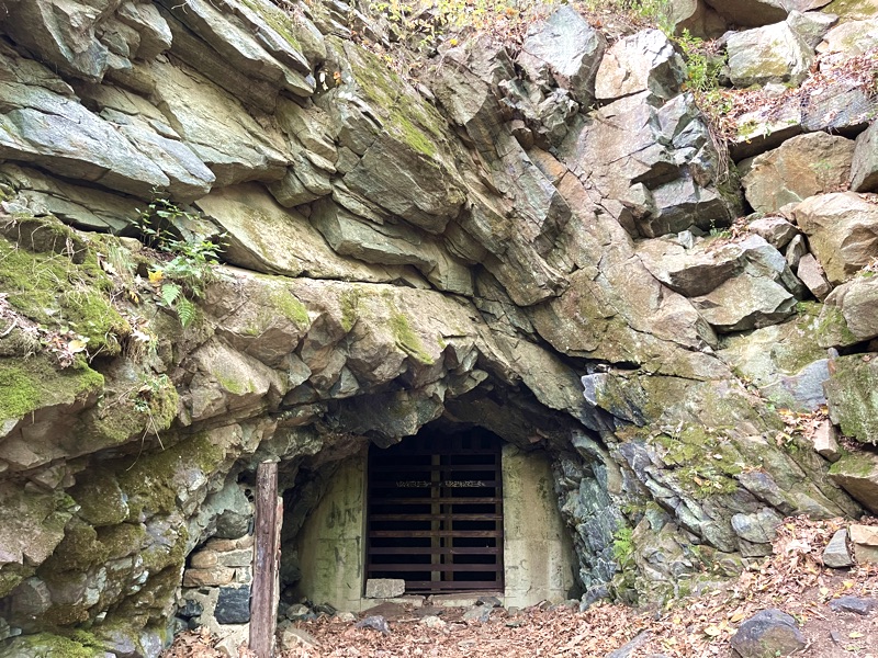
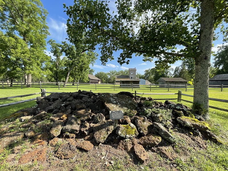
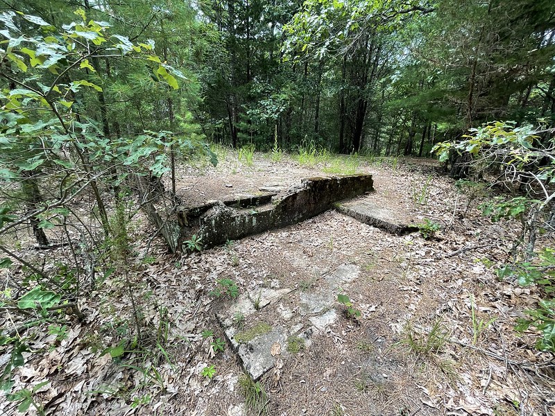
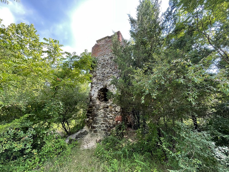
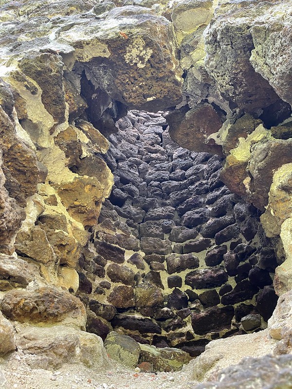
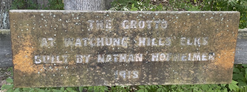
Long story short: there was a guy named Nathan Hofheimer who had a copper mine in Warren, NJ. When the copper mine gave up all the copper it could, Hofheimer filled it with water and surrounded it with a semi-circular, multi-level structure made from rocks pulled from the mine, creating the impressive and eponymously named, Hofheimer Grotto. More info about the copper mine on Mindat.org.

Grotto Plaque

Grotto

The Grotto is currently the property of Elks Lodge 885. It’s open to the public and can be found at 99 Bardy Rd, Warren, NJ, nestled in the woods on the Elks Lodge property.

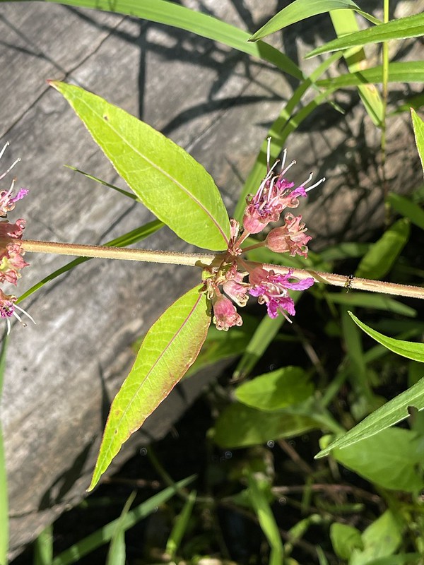
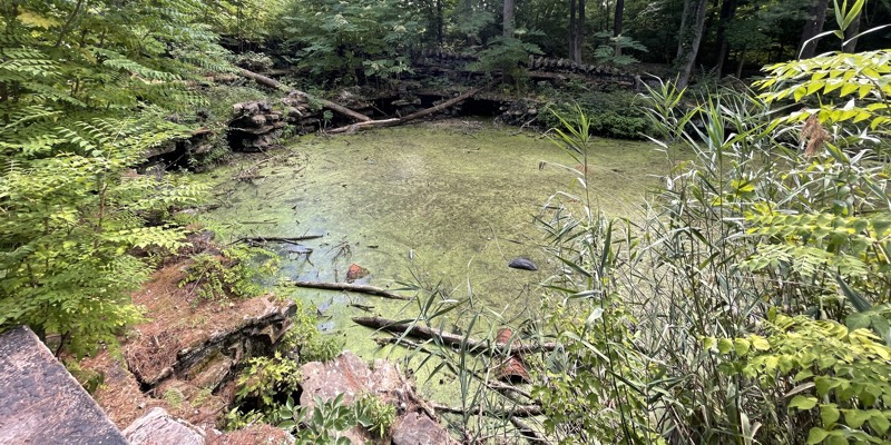
Sadly, the Grotto has fallen into disrepair. People throw tires, shopping carts, picnic tables, and every kind of trash you can imagine into the Grotto orifice — masks, vape cartridges, dental floss picks, blue bags filled with canine excrement, beer bottles, pizza boxes, Monster energy drink cans — it’s all in there. On top of the garbage, the Grotto is overgrown with all manner of weeds, including the thick-trunked Tree of Heaven (Ailanthus altissima), which attract the lousy Spotted Lantern Flies that parasitize them. The water in the Grotto is stagnated and green. It doesn’t smell bad though, which is good.

Regardless of the decay, the Hofheimer Grotto is worth checking out. I climbed its Roman coliseum-like structure and chilled for about 30 minutes. Greeted dog-walkers as they entered the park. It was nice.

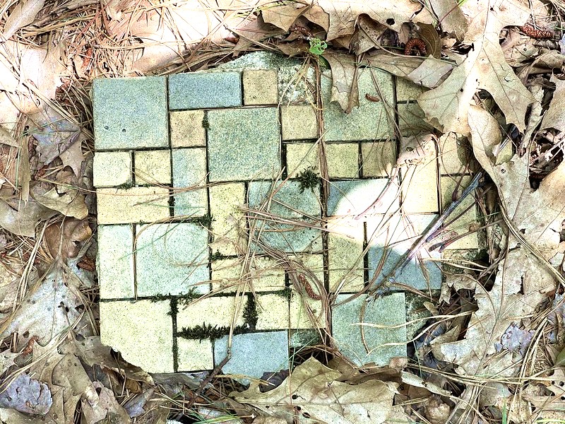
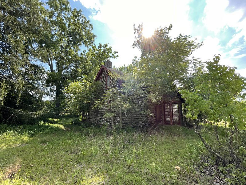
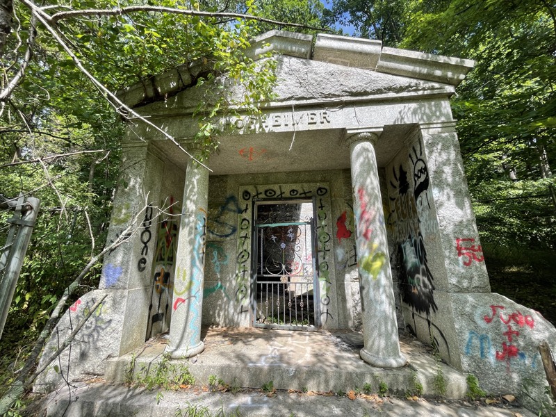
South-east of the Grotto, you’ll find the Hofheimer Cemetery. I found the Mausoleum, which was totally desecrated, slathered with spray paint, and had a collapsed roof. I walked the nearby trails and saw some mounds that looked human-body-sized.

Hofheimer Cemetery

So what can be done?

I’ve read that part of the problem is getting power to the Grotto to power lights and a fountain to keep the water from stagnating. Allegedly, Warren Township and the Elks need to cooperate on this, and they can’t agree on a path forward. Maybe, solar to make everyone happy? Then get a team of volunteers from the Lodge, a wood-chipper, chainsaws, and a dumpster, and get rid of the brush. Pump put the water. Fix or put in the fountain. Put in some lights. Rainbow LED fountain lights. Make it safe for families. Fix up the cemetery. I’m willing to help.

Hibernia cave

Hibernia Bat Mine Mine in Hibernia, New Jersey

Nestled in a hillside in Hibernia, New Jersey, you’ll find the Hibernia mine (mindat.org page). In the 18th and 19th centuries, New Jersey was a top location for iron production. In the south there was bacteria-created “bog iron”, and in the north, in places like Hibernia, magnetite, magnetic iron ore, was torn from the bellies of mountains.

Map of The Hibernia Mines

It took me a while to find the mine. The trail, starting at the trailhead at Green Pond Road & Lower Hibernia Road, forks in several places. One path leads to the graffitied ruins of a building, one leads to a pile of mine tailings, one leads to more ruins…

Hibernia  ruins

… and the top of the mountain, and one — the one you want — that heads toward the mine. Starting from the trailhead, I think it’s the second fork on the right; you walk up a hill and when you see what looks like the back of someone’s backyard, take the train on the left. When you get near the cave, you’ll feel the air get colder. There’s a wood platform on the left and on the right the final path to the mine.

As you get closer…

Approaching Hibernia Mine

And closer to the mine entrance, you’ll notice the air coming from the mine is very chilly…

Hibernia Mine entrance

Freezing cold, in fact.
Hibernia Mine a chilly 30 degrees

The mine is sealed off to protect it, and the bats who live there, from vandals and ne’er-do-wells. Though you cannot explore inside, what can be seen from the outside is visually impressive, and the cool air is a refreshing treat on a hot summer day.

Geologically speaking, you’ll find all kinds of interesting rocks in the park surrounding the mine: massive glacial erratics, purple & white “pudding stone”, pink granite, magnetite, biotite, milky quartz, and lots of banded, and some folded, gneiss. Migmatite, maybe?

In terms of hiking and discovery, throughout the park, you’ll find the collapsed entrances to mines, piles of tailing from mines, a cemetery for miners, stone ruins of building used to process ore, massive bear turds, and plenty of beautiful New Jersey nature.

Cliffwood Beach used to have cliffs made of prehistoric wood & amber

Cliffwood Beach, a community in Aberdeen, New Jersey, used to have cliffs made of prehistoric wood called lignite & amber. The cliffs have been covered with rock and concrete to prevent erosion, but if you’re patient, you’ll eventually find some lignite, marcasite, and even amber on the shore. Other than lignite and marcasite, I’ve found siderite, fossils, blue crystals, jasper, green basalt, almost-clear quartz pebbles, and human artifacts like electrical insulators and old bricks. Unlike the New Jersey beaches along the Atlantic Ocean, Cliffwood Beach is a beach of Raritan Bay. Don’t expect big waves, a boardwalk, or the cast of the Jersey Shore. Do expect some interesting rocks and artifacts.

Mindat page for Cliffwood Beach.

Lignite with Maracasite:
Lignite with Maracasite

Whale Creek
Whale Creek

Cliffwood Beach: plenty of rocks, clay, and old iron from buildings and boats.
Cliffwood Beach

Iron-stained quartz:
Iron-stained quartz

Fossils:
Fossils

Walking around Hammonton, New Jersey

Hammonton, New Jersey is a large, rectangular town located in the New Jersey Pine Barrens. It is known as the blueberry capital of the world. I found it interesting for its microbrews, in particular, Chimney Rustic Ales. Their purple Wave Water is unique and tasty.

Wave Water

I only spent an hour in town, but a walked a few blocks and liked what I saw.

Unusual architecture:
Hammonton, NJ

A good antique/collectables store: Vintage Betty’s.
Vintage Bettys

Ghost signs:
Ghost Sign

This sign:
Welcome to Hammonton NJ

Cow chairs:
Cow Chairs

Batsto Village in the New Jersey Pine Barrens (Jersey Devil?)

Batsto Village (website), located in Wharton State Forest in New Jersey, is a preserved and restored village that once manufactured iron and glass. The village contains many well-maintained 19th-century buildings, a museum & gift shop, the Mullica River, and Pine Barrens hiking trails. History & nature — something for everybody. There’s also a connection to the Jersey Devil.

Batsto Mansion:
Batsto Mansion

A large sample of the bog iron that was used for iron manufacturing:
Bog Iron

The Mullica River is dammed at the site of the village to power a mill (or two). The Mullica is a favorite of kayakers, but maybe not at this exact location. It was previously known as the Batsto river.
Mullica River

The nature trails are loaded with opportunities for naturalists and photographers.
Mushroom

Batona Trail

1936 Wildland Firefighter Memorial, Bass River State Forest

There’s a Wildland Firefighter Memorial located along East Greenbush Road in Tuckerton, New Jersey, in Bass River State Forest. In the woods behind the memorial, there are foundations of buildings from a former Civilian Conservation Camp (1933-1942). If you walk the trails and explore the woods, you’ll find foundations, slab floors, chimneys, and other chunks of old buildings.

The Pine Barrens are prone to fires, in part, due to the flammability of pine sap. Sadly, fires occasionally take the lives of the brave fighter fighters who protect the Pine Barrens.

The slab floor of the building:
Wildland Firefighter Memorial, Foundation

A chunk of tile from a bathroom:
Wildland Firefighter Memorial, Tile Floor

A lichen that looks like the outline of a cartoon alien:
Wildland Firefighter Memorial, Lichen that looks like an alien

Other stores about the Pine Barrens:

Atsion Furnace in the Pine Barrens

The thing with Google Maps is… it thinks you’re driving a monster truck. Countless times Google Maps has directed me to take my front-wheel-drive sedan down single-lane mud roads with potholes the size of small vernal ponds.

Think I’m joking? Look at this big chungus:
Huge pothole

Sometimes these navigational mulligans lead to an interesting find, like the Atsion furnace. After backing my feeble vehicular contrivance out of the mud and craters death trap road, I took the next lane over. That turned out to be a dead-end — the “Mullica River Canoe Launch” — there was a small dirt parking lot for kayakers and the cola-colored Mullica river. The water in the Pine Barrens is really cola-colored: pitch black at its deepest parts and translucent brown at its edges. I’ve heard the color comes from tannins from pines and/or the bacteria that create bog iron.

As I turned around I noticed a tall (maybe 15′) stone structure resembling a furnace or kiln. I parked the car and investigated. At the base of the structure were layers of charcoal and a scattering of bog ore. Oyster shells — used as a flux for making iron — were also present. I took some photos and walked the nearby grounds, finding the ruins and foundations of many small buildings, and remnants of the New Jersey Southern Railroad.

Atsion Furnace:
Atsion Furnace

A look inside

Remnants of the New Jersey Southern Railroad:
the New Jersey Southern Railroad

Intrigued, I researched the area and it turned out the structure is called the Atsion furnace. I bought a book on eBay called Atsion: a Town of Four Faces by Sarah W.R. Ewing. According to her book, Atsion has had a long history of industrious investors and entrepreneurs, starting in the 1700s. Atsion has been home to industries as diverse as iron refining, iron casting, charcoal manufacture, lumber cutting, paper milling, ice harvesting, and farming cranberries, blueberries, and other fruits & vegetables. I think the only enduring industry has been farming.

Dilapidated house:
Abandoned house

Kayakers, history buffs, and urban explorers will enjoy this location.

More Pine Barren stories:

The Franklin Parker Preserve and abandoned railroad tracks

Back in July, I was hanging out in the parking lot of the Brenda T Byrne State Park welcome center, waiting for the sun to set so I could get some video of Northern Dusk-Singing cicadas singing. These cicadas, as their name suggests, sing after the sun has set. I located a male cicada perched in a tree close to the ground and was poised to film it singing when I noticed the silhouette of a man appear in the distance manifesting like a ghost out of the haze of twilight. He walked directly toward me. Was he a ghost? Was he a serial killer? Turns out the guy was a trucker who liked to hike and stopped by to get some information about the park. We talked for a while and he gave me some tips about other local parks and trails like the Franklin Parker Preserve. The trucker was intrigued by the abandoned train tracks that ran through much of the Pine Barrens as well. I missed getting a video of the cicada singing, but I got some good tips on new trails, and later I snagged a cicada nymph which I was later able to watch molt.

Chatsworth Lake, across the road from the entrance to The Franklin Parker Preserve:
Chatsworth Lake

The Franklin Parker Preserve, maintained by the New Jersey Conservation Foundation, is located in Chatsworth, New Jersey, not far from Hot Diggity Dog and the Brooksbrae Terracotta Brick Factory. Ecologically speaking, it is prime Pine Barrens: sandy soil, with obvious dunes in some places, multitudinous pine trees, blueberry bushes, oaks, and a black-water river. The hiking trails are scenic: winding through forests, over dunes, alongside and over swamps, and the West Branch Wading River. The park is recommended for everything from horseback riding, to fishing, to bird-watching — as a naturalist, and someone who enjoys finding abandoned stuff in the woods, it’s a most excellent place to explore. The cicadas you’ll find in the park are the Pine Barrens cicada (June-early July), the Northern Dusk-Singing cicada (July-August), and the Dog-Day cicada (late July-September).

The quiet, cola-black waters of the West Branch Wading River:
Cola-black water

The abandoned railroad:
Franklin Parker Preserve railroad

I’m sure a lot of folks will ignore the railroad that bisects the park, but like the Trucker, I was intrigued. The main hiking trail crosses the railroad — just a step or two and you’re over it. But, if you follow the tracks northeast, you’ll discover a decaying train bridge made of timber, that crosses the West Branch of Wading River. If you go southwest your path will be blocked by a pine forest. The railroad is the New Jersey Southern Railroad. If you start at Franklin Parker on Google Maps satellite view, you can trace the path of the railroad north to Raritan Bay, and south to Vineland, bisecting the Pine Barrens. You can catch glimpses of it alongside the Brooksbrae Terracotta Brick Factory and in Atsion near the abandoned furnace. Over the years the Pine Barrens has been home to many industries including bog iron harvesting, iron forging, charcoal manufacture, lumber, brick making, glass making, paper mills, ice harvesting, and farming cranberries and blueberries. Trains were needed to transport these goods north to New York and west to Philadelphia (the New Jersey Southern Railroad connecting to the Camden & Atlantic and/or Atlantic City lines). With little manufacturing in the area, starting in the mid-20th century, there’s been little need for a railroad. The forest has reclaimed the land, but the ghost of the railroad remains.

More from the Pine Barrens:

Dot and Brooks Evert Memorial Trail Preserve (New Jersey’s Spookiest Hike)

The Dot and Brooks Evert Memorial Trail Preserve is located in the middle of New Jersey on the north-western edge of the Pine Barrens. It is near Brendan T. Byrne State Forest, the Michael Huber Warbler Preserve, and an entrance to the 53.5-mile Batona trail. The preserve is maintained by the New Jersey Conservation Foundation. The entrance is along the curiously named Ong’s Hat road; it is easy to miss, especially if someone is tailgating you while you’re trying to find it.

Evert Trail

It is near the ecological border between the Pine Barrens and the divide between inner and outer coastal plains. You won’t find the sandy soil and multitudinous pine trees typical of the Barrens — instead, the Evert Trail Preserve is mostly swamp, streams, and trees growing from small lumps of ground periodically rising above the swamp. This is a unique experience! The trail is constructed from planks of wood seemingly floating on top of the swamp. It’s not for horses, bicycles, or ATVs — I weigh north of 250 pounds at the moment, and there were times I was sure I would sink. Good balance and concentration are necessary. This trail/preserve is best for hikers, naturalists, and birders.

Spoilers! Here is a video of part of the trail:

Along the way you’ll see hundreds if not thousands of different types of swamp-loving fungi and plants like this Swamp Loosestrife (Decodon verticillatus):
Evert Trail Swamp Loosestrife

And even though it is 50 minutes from Leeds Point, I’m sure the Jersey Devil has been here. It’s the spookiest and most memorable trail in New Jersey.

More stories from the Pine Barrens: